Tech Vaidya WhatsApp Channel
Get AI updates, tech news, cybersecurity alerts and useful tech tips directly on WhatsApp.

| Nagaraj Vaidya
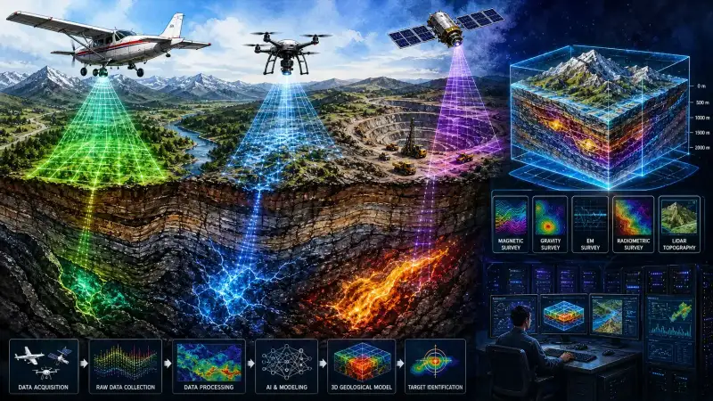
There was a time when the only way for scientists to know what lay beneath the earth's surface was to dig deep into the ground. Whether in the scorching heat or freezing cold, physical surveys in dense forests and rugged terrains took years of manual labor, breaking rocks, and analyzing soil samples. Today, technology has completely relegated those traditional hardships to the pages of history. The small aircraft, drones, and satellites silently cruising through the skies above us have fundamentally rewritten the rules of subterranean exploration.
This is not just routine aviation; it is a highly sophisticated digital operation that scans hundreds of feet below the earth's surface with pinpoint accuracy. The National Aero-Geophysical Mapping Program (NAGMP), spearheaded by the Geological Survey of India (GSI), is continuously executing these missions across the country. Conducted in collaboration with private entities like Aquila Drilling, this aerial survey has emerged as a monumental milestone in the mineral exploration sector. In an era driven by the electric vehicle revolution and advanced electronics, locating critical minerals like lithium, cobalt, and rare earth elements has become an absolute necessity.
Scanning the Depths from the Heavens
To scan the earth from above, survey aircraft fly at astonishingly low altitudes, typically maintaining a clearance of just 80 to 100 meters from the ground. There is a very specific scientific reason for this risky maneuver. According to the laws of physics, the strength of the subtle magnetic and gravitational waves emitting from the earth's surface diminishes exponentially with distance. Therefore, the closer the sensors are to the ground, the more accurate and crisp the data becomes. The magnetometer, a highly sensitive instrument mounted on the belly and wings of the aircraft, is the primary weapon in this operation.
If massive deposits of iron, nickel, or other magnetic minerals are hidden underground, they cause minute disruptions in the earth's natural magnetic field at that specific location. The magnetometer captures these magnetic anomalies with incredible precision. The aircraft flies at a constant speed, mapping the sky in a tight grid pattern, collecting thousands of data points every single second. This continuous stream of information allows scientists to estimate exactly where, at what depth, and what type of mineral deposit is lying dormant.
The Marvel of Gravity and Electromagnetic Waves
The mention of gravity instantly brings to mind the story of Newton and the falling apple. While the earth's gravitational pull appears uniform to the naked eye, scientifically, there are microscopic variations based on the density of the rocks and minerals beneath the surface. In areas concealing heavy mineral deposits like gold, lead, or copper, the gravitational force is infinitesimally stronger than normal. An instrument called a gravimeter, housed inside the aircraft, measures these delicate shifts to calculate the exact density of the hidden geological structures.
 Why Is Typing Kannada on Apple Laptops Still So Difficult? Which Kannada Keyboard Is Best for Apple Computers?
 Apple Finally Folded the iPhone! Why the iPhone Duo Could Change the Smartphone Industry
 TechVaidya: One Year. Over a Thousand Articles. And a long road still ahead...
 NASA Invites ISRO to Join the Moon Base Mission: Why This Could Be a Turning Point for India
 Toxic Review: Yash Owns the Screen, But Does the Film Own the Story?
Another incredibly impactful technology utilized in these flights is the electromagnetic survey, which essentially acts as a colossal metal detector sweeping across the landscape. The aircraft transmits specific electromagnetic waves downwards into the earth, penetrating hundreds of feet into the bedrock. If these waves encounter highly conductive metals, the metallic bodies absorb the energy and generate their own secondary electromagnetic field, reflecting it back to the surface. Receivers on the aircraft capture these returning signals, creating a conductivity map of the subterranean world.
The Drone Revolution in Hostile Terrains
Fixed-wing aircraft have their limitations. Flying at dangerously low altitudes over steep hills, deep valleys, or treacherous forest canopies like the Western Ghats is virtually impossible and highly risky. To overcome these geographical challenges, unmanned aerial vehicles (UAVs) or drones have injected new momentum into geophysical mapping. Capable of flying even lower than planes—often just 30 meters above the ground—these drones gather ultra-high-resolution data. Being highly cost-effective and agile, drones are now playing a pivotal role in mapping the subterranean depths of the most inaccessible regions on the planet.
Radiometric surveying, which detects radioactive elements present in the earth's top layers, is another crucial component of this exploration. Gamma-ray spectrometers are deployed to measure the natural gamma radiation emitted by elements like uranium, thorium, and potassium. This technology is indispensable for scientists seeking nuclear fuel sources for power plants, as well as for understanding the chemical composition and geological weathering of surface rocks.
The Eagle Eye of Satellites and LiDAR Technology
Alongside aerial surveys, satellite-based technologies in the vacuum of space are operating like an eagle's eye to unlock subterranean secrets. Hyperspectral imaging technology is at the forefront of this space-based exploration. As sunlight hits the earth's surface, different rocks and soils reflect specific wavelengths of light. Because every mineral has a unique spectral signature—essentially a fingerprint of reflected light—the sensors on these satellites continuously analyze these wavelengths. By detecting subtle color variations completely invisible to the human eye, scientists can map the probable locations of specific mineral belts across vast continents.
Surveying heavily forested areas has historically been a massive headache for geologists, as the thick canopy of trees conceals the actual shape of the ground below. However, Light Detection and Ranging (LiDAR) technology has effortlessly solved this decade-old problem. By firing millions of laser pulses, LiDAR penetrates the dense forest canopy to create an exact 3D topographical map of the bare earth. The laser beams slip through the tiny gaps between leaves and branches, hit the ground, and bounce back, painting a vivid and hyper-realistic picture of the geological structures hidden beneath the forest floor.
Data Challenges and the Creation of Digital Twins
The sheer volume of data generated daily by all these advanced technologies is staggering. However, this raw data is far from pristine. As survey planes fly over human infrastructure, elements like high-tension power lines, railway tracks, mobile towers, and even cosmic events like solar flares create massive amounts of "noise" or interference in the readings. The first major challenge for data scientists is to meticulously filter out this chaotic interference and isolate the authentic geological signals using highly advanced software algorithms.
Once purified, this mountain of information is fed into supercomputers. This is where artificial intelligence and deep mathematical modeling begin their magic. The AI software analyzes the massive datasets to create a highly accurate 'Digital Twin' of the earth's subsurface. A Digital Twin is a realistic, interactive virtual replica of the physical world. Through this 3D model on a computer screen, scientists can visually peel back the layers of the earth, understanding the complete geological history of a region and pinpointing exactly which mineral is hiding in which strata.
Environmental Protection and the Dawn of a New Economy
The greatest triumph of these modern technologies is the absolute protection they offer to the environment. In a country with diverse and ecologically sensitive geographical formations like India, traditional drilling and excavation methods caused irreversible damage to forests and wildlife. Today's aerial and satellite technologies are completely eco-friendly. Apart from the temporary noise of a passing plane, these surveys do not harm a single blade of grass. The era of blindly cutting down miles of forest and digging up the earth in vain is officially over.
From an economic perspective, this precision is critical for the nation's future. The revolution in electric vehicles and the modern electronics industry has skyrocketed the demand for critical minerals. Instead of relying heavily on foreign imports, accurately locating the deposits within our own borders is the ultimate symbol of economic self-reliance. Thanks to this technological leap, mining companies no longer have to blindly pour billions of rupees into random excavations; they can now invest surgically, exactly where the minerals exist.
The symphony of physics, artificial intelligence, and aviation technology has given a profound new dimension to human exploration. Once the aero-geophysical mapping of the entire country is completed from the skies, we will possess a crystal-clear, highly accurate picture of our nation's mineral wealth. This monumental database will not only revolutionize mining but will also serve as a robust foundation for groundwater exploration, seismic studies, and massive infrastructure development. The small planes and drones flying quietly above our heads are, in reality, carefully drafting the economic destiny of the nation.
❤️ Also Read
❤️Beyond the Blade: How Gene Editing is Rewriting the "Death Sentence" of Cancer?
❤️From Coder to Creator: The Brutal Reality of Making Money in the AI Era
❤️The Death of the Curated Grid: Say Hello to Instagram’s Newest "Authentic" Experiment!
❤️Our 'Photographic Memory' and AI's 'Digital Alzheimer's'!
❤️The Looming Shadow of Waste over Manki Marine Sanctuary: A Paradise Under Threat
❤️The Illusion of Algorithms: Read This Before You Get Trapped!
❤️Private Servers on Military Soil: The US Army’s Unprecedented Tech Gamble!
❤️Silicon Hubris vs. Regulatory Reality: Why Being a Tech Giant Didn’t Save Paytm from the RBI’s Axe
🟢 Follow our WhatsApp Channel JOIN ➤
🛒 ಆನ್ಲೈನ್ ಶಾಪಿಂಗ್ ಮಾಡುವಾಗ ಈ ಕೆಳಗಿನ ಲಿಂಕ್ ಬಳಸಿ

No Comment Yet.
Stay informed with breaking news, trending stories, and in-depth analysis.